


MAP THE INACCESSIBLE
Autonomous SLAM-based LiDAR mapping
Building on a decade of pioneering research at the Commonwealth Scientific and Industrial Research Organisation (CSIRO), Emesent offers state-of-the-art autonomous SLAM-based LiDAR mapping and data analytics solutions specifically designed for challenging and GPS-denied environments.
Providing fast, accurate and long-range scanning, Emesent Hovermap helps businesses map the unknown, minimizing operational downtime while improving worker safety.
Emesent excels at mapping the inaccessible
Emesent is an expert in autonomous LiDAR mapping. We help companies visualize and understand their environments by mapping the inaccessible. Here’s what you need to know about our latest developments.

Hovermap’s new option for airborne survey missions
Emesent partners with Pointerra to provide end-to-end workflows for LiDAR and panoramic imagery
Learn More
The Role of Autonomous Robots in Post-Blast Mining

Emesent’s leading solution for mobile mapping
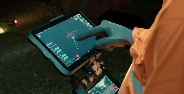
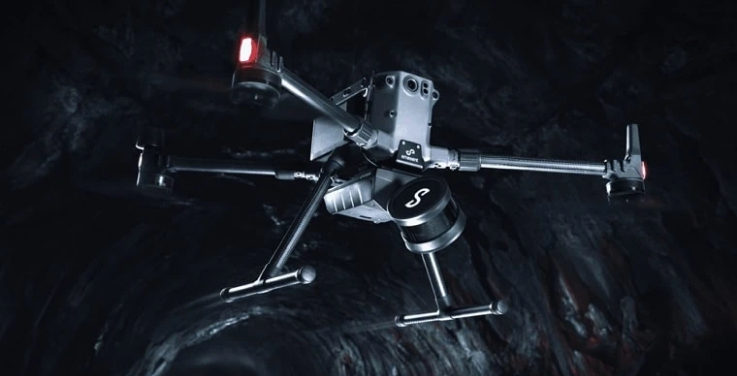
At the heart of our offering is the award-winning Hovermap system, a highly versatile scanner supporting a range of deployment options. Hovermap is suited to a variety of different industry surveying scenarios. Our key strengths are delivered via point cloud quality, autonomous capabilities and the overall versatility of our mobile mapping platform.
AUTONOMY
Advanced autonomous mapping for complex mining, engineering, and public safety operations.
VERSATILITY
Plug-and-play accessories and capability enhancing add-ons – for diverse mapping missions.
Emesent enables action from spatial insights
The value of Emesent’s powerful hardware and software solution has been in delivering actionable spatial insights for businesses operating in hazardous and inaccessible environments. Here are some of our clients’ compelling stories.
Glencore Kidd Operations Stope Mapping

“Kidd Operations is an enthusiastic adopter of new technologies like Hovermap, that improve safety and mining efficiency.”
Osprey Integrity Speeds up Natural Disaster Recovery with Fast, Accurate Data Capture

“With Hovermap, we were able to capture the structure from all sides. This even included getting Hovermap close to the river to capture the underside of the bridge, ensuring the downed girders were included in the data.”
Barrick Bulyanhulu and Kibali: Stope Scanning

“Shadowing is obviously a big part of what we were trying to eliminate. With the CMS, you’ve just got one position and if you’ve got an edge, it doesn’t scan at the bottom, past that edge. By contrast, the Hovermap is going down and picking up all the small places the CMS didn’t.”
How Emesent Hovermap technology helped Petra Diamonds save millions

“We lowered Hovermap down ore passes, flew the drone into drawpoints and even scanned our shaft and ramps by fixing the scanner to one of our vehicles. The visualization delivered exceeded all our expectations. The data captured in one ore pass saved us significant time and effort by confirming it was irreparable. That saved us millions.”
Business Benefits from Autonomous Mapping
The fast and accurate capture, processing, and visualization of data captured through autonomous mapping allows businesses to maximize their productivity while improving workplace safety. Find out how Emesent Hovermap is being used across a diverse range of industry applications.
Connect with us at Emesent
As a customer or partner you are joining a growing community of experts who are using SLAM-based LiDAR technology to better understand the world. By logging in, you have access to a range of resources to help make the most of the Emesent platform. Or, if you are just starting on your journey to map the inaccessible, contact us now to find out more. We’re keen to hear from you.